Water Line Detector
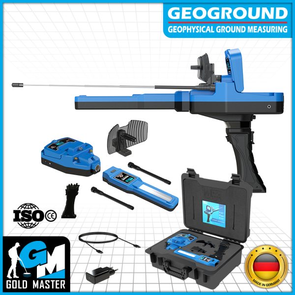
Discover a groundbreaking innovation in groundwater detection technology with the Water Line device, the extraordinary water detector device brought to you by Geoground.
Prepare to embark on a journey of exploration as we delve into the depths of groundwater mysteries like never before.
Water Line is a powerful and easy-to-use groundwater detector device that harnesses cutting-edge Long-Range locating technology to revolutionize how we uncover water sources underground.
Equipped with unparalleled capabilities, it has the power to detect normal, fresh, and even salty water sources, offering an all-encompassing solution for water exploration.
With an impressive scan range that spans an incredible 3000 meters and a remarkable depth penetration of up to 1200 meters, Water Line takes you to new frontiers in your quest for hidden water reservoirs.
Whether you are a professional geologist, a dedicated hydrologist, or an avid water explorer, Water Line is your ultimate companion in unraveling the secrets beneath the Earth’s surface.
Join us on this extraordinary journey as we unveil the true potential of Earth’s water resources. With Water Line by your side, you have the power to unearth the most elusive water sources, transforming the way we understand and utilize this precious and life-sustaining element.
Applications and uses of the Water Line
– Groundwater Exploration: Water Line is designed specifically for the detection and exploration of groundwater sources, allowing users to locate and map underground water reservoirs.
– Water Resource Management: The device aids in assessing the quantity and quality of water resources, assisting in sustainable water management and conservation efforts.
– Agriculture and Irrigation: Water Line can help farmers and agricultural professionals identify suitable areas for well placement and irrigation, optimizing water usage and crop productivity.
– Geological Surveys: Geologists can utilize Water Line to map geological structures, identify potential aquifers, and understand the hydrogeological characteristics of an area.
– Water Well Drilling: The device assists drilling companies in determining optimal drilling locations, increasing the success rate of well installations, and reducing drilling costs.
Water Line Features
Long-Range Locating Technology for Groundwater Detection
Water Line, a groundbreaking groundwater detector device harnesses the power of Long Range Locating (LRL) technology to locate underground water resources remotely from long distances.
With Water Line, users can customize the search process to get accurate results, as they can precisely set the scan range and depth range, allowing them to target specific areas with utmost accuracy.
This remarkable performance is made possible through antennas, Signal Booster Dish, and the cutting-edge Smart Sensor, ensuring unparalleled detection accuracy and efficiency.
With Water Line, uncovering hidden groundwater resources has never been easier or more efficient.
Detection Tools
The Water Line groundwater detector device utilizes a sophisticated combination of antennas, a Signal Booster Dish, and a Smart Sensor to detect and locate groundwater resources effectively.
Together, these components work harmoniously to form a comprehensive detection system.
The antennas capture electromagnetic signals, the Signal Booster Dish enhances the signal reception, and the Smart Sensor collects and analyzes the scan data.
By combining the information gathered from these components, Water Line can accurately determine the location of groundwater sources, empowering users to make informed decisions regarding water exploration and management.
Search Antennas
Antennas act as primary receivers for electromagnetic signals resulting from electromagnetic fields generated because of the presence of underground water resources and deposits and propagating through different layers of soil and rock formations.
Since these waves encounter differences in electrical conductivity and permittivity to the ground, they are subject to modifications in their frequency, amplitude, and phase and the device receives the resulting signals and converts them to digital signals for analysis within the device.
Signal Booster Dish
The Signal Booster Dish plays a vital role in enhancing the reception of the signals mentioned in the previous paragraph.
It works to amplify the weakest electromagnetic waves emitted in order to ensure greater accuracy in determining the location of the water source.
Smart Sensor
The Smart Sensor is a highly advanced component that integrates advanced sensing technologies via its built-in electronic sensors and works in conjunction with antennas and signals booster dish to collect and interpret data from received signals below the surface to guide the user to the accurate position of possible water resources.
An important feature of the smart sensor is that the small LED lights located at the top of it light up in blue color when it senses the presence of a nearby underground water source.
The Smart Sensor is capable of detecting subtle variations in the ground’s electromagnetic fields and electrical properties, providing valuable insights into the presence and characteristics of groundwater resources.
Customized Search Options
The Water Line device provides a very simplified and easy user experience for the user in order to search for groundwater sources.
However, it provides a set of options that customize the search process to suit the user’s needs, drilling capabilities, and the nature of the land.
Options that the user can adjust and customize include the following
Type of Water
Water Line devices enable the user to select a water type, allowing users to specify the specific type of water they are searching for within the target area.
The device can detect three primary water types:
1 – Normal Water: which refers to standard groundwater.
2 – Fresh Water: denoting clean and non-saline water sources
3 – Salty Water: indicating the presence of saline or brackish water.
By choosing the desired water type, users can tailor their search to focus on a particular category of water resources.
Distance
This feature allows users to indicate the search range within the target area.
By utilizing this option, the user can specify the distance that the Water Line device should cover while conducting its search.
Remarkably, the device has the capability to search for distances of up to 3,000 meters, highlighting its impressive wide scan range.
With such extensive coverage, users can explore expansive territories when seeking out potential water sources, making the device highly efficient and effective in its groundwater detection capabilities.
The user can adjust the distance value accurately within the range from 0 to 3000 meters
Depth
This feature indicates the maximum depth of the scan range within or beneath the target area.
The Water Line device excels in its capacity to detect water sources that are as deep as 1600 meters underground, enabling it to uncover a significant majority of targets within the search area.
Furthermore, the device’s exceptional capabilities extend to accessing previously unreachable water reservoirs at such impressive depths. With this capability, Water Line empowers users to tap into previously unexplored water sources, expanding the possibilities for discovering valuable groundwater resources.
The user can also set the depth value accurately within the range from 0 to 1600 meters
Scan
Once the user has selected the desired settings, he has the choice to initiate the search, commencing the scanning process.
At this stage, he can review all the settings previously specified. It is crucial to confirm that the chosen settings align with his search requirements.
Starting the scanning process is simply done by pressing the OK button on the keypad.
Upon completing the initial settings, a warning window will appear, prompting us to press either the Start button or the OK button on the keyboard to initiate the calibration and enter the search screen that guides the user through visual indicators to the target location.
Easy-to-Use Multilingual Program
The software program of the Water Line device showcases an appealing graphical user interface (GUI) that features a modern design and maintains a consistent color scheme.
The interface utilizes a single menu system with distinct tabs for settings, accompanied by expressive icons that represent each option and setting visually.
This thoughtful design enhances user experience by facilitating the selection of various options in a seamless and visually intuitive manner.
Additionally, the device interface offers customization options for various general settings. These settings include Date and time for synchronization, screen settings such as Brightness adjustment, sound settings such as Key Sound Volume and Scan Sound Volume control, language selection for the program, and the display of general information like the serial number and other relevant details.
This comprehensive set of customizable options allows users to tailor the Water Line device to their specific preferences and requirements, ensuring a personalized and user-friendly experience.
Languages
In order to cater to a wide range of prospectors globally, Geoground has incorporated a language customization feature into the user interface of the Water Line device.
Users now have the option to select their preferred language from a carefully curated set of languages, including:
English – German – Spanish – French – Russian – Italian– Arabic – Persian.
By offering this diverse selection of languages, Geoground ensures that Water Line devices can be easily accessed and utilized by prospectors from various linguistic backgrounds, promoting inclusivity and usability on a global scale.


Reviews
There are no reviews yet.